
Land Acknowledgment: Payahuunadu has been, and continues to be, the homeland of the Paiute (Nuumu), Shoshone (Newe), and Timbisha peoples. This land acknowledgment honors the original inhabitants of the Eastern Sierra and the tribes who remain here today.
Overview
Tucked behind the Mammoth Crest, the Deer Lakes Loop is a hidden gem that serves up high-elevation meadows, alpine lakes, and sweeping Sierra views. This moderately challenging 12.9-mile loop rewards those willing to go the distance with quiet solitude and incredible backcountry scenery—without needing a permit for day use. It’s the perfect day-long adventure for experienced hikers looking to explore beyond the popular Mammoth trails.
Trail Beta
| Trailhead | Coldwater Campground |
| Route | Deer Lakes Loop via Duck Pass Trail and Pika Lake Trail |
| Mileage | 12.9 miles |
| Elevation Start | 9,100 feet |
| Elevation Gain | 2,200 feet |
| High Point | 11,150 feet |
| Type | Loop |
| Difficulty | Moderate to Strenuous |
| Water | Seasonal streams and lakes—treat before drinking |
| Permit | Overnight |
| Pets | Yes, on leash |
| Land Manager | Inyo National Forest |
Trail Description
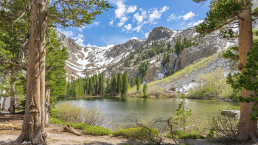
The trail begins at the Duck Pass Trailhead at Coldwater Campground and shares the route with the popular Duck Pass Trail before veering east toward Deer Lakes via the Mammoth Crest. After passing scenic Arrowhead and Skelton Lakes, you’ll gain elevation quickly as you ascend to the Mammoth Crest ridge.
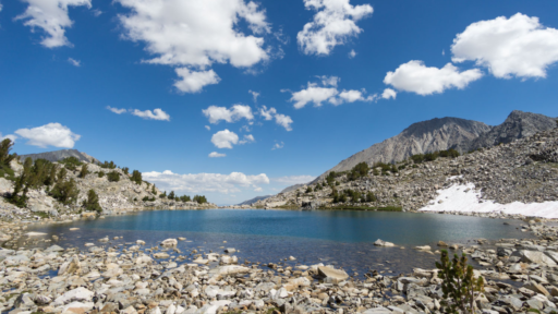
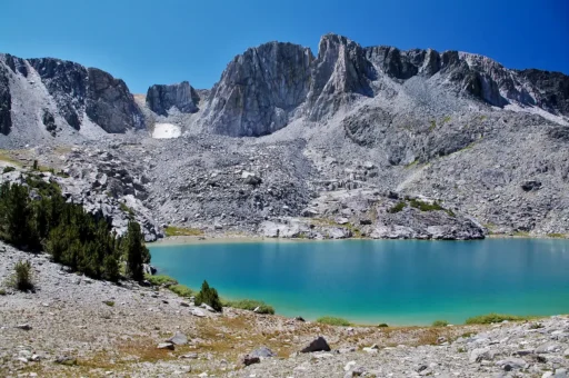
At the top, take in panoramic views of the Ritter Range and the Silver Divide. From here, the loop dips into the basin that cradles Deer Lakes—three beautiful alpine lakes set against a rugged granite backdrop. You’ll loop around the lakes and descend via a lesser-known trail that reconnects near Lake George. The trail is well-maintained but steep and exposed in parts—so start early and pack plenty of water.
Best Season to Hike
July through October. Snow lingers into early summer, so wait until trails are clear. Wildflowers peak in July, and fall colors add a golden glow in late September.
Flora & Fauna
Expect to see mule deer, marmots, and maybe even a pika if you’re quiet. The trail traverses lodgepole and whitebark pine forests, with pockets of wildflowers like Sierra columbine, lupine, and paintbrush in early summer. Keep your eyes on the sky—golden eagles and red-tailed hawks often soar overhead.
Geology
Deer Lakes sits on the eastern edge of the John Muir Wilderness, in terrain shaped by volcanic activity and glacial carving. You’ll traverse ancient granitic domes and walk through basins gouged out during the last Ice Age. The dramatic rise of the Mammoth Crest offers a textbook view of fault block uplift.
History
This area has long been part of the homelands of Indigenous Paiute peoples, who moved seasonally through the high country. In the 20th century, these trails gained popularity with anglers and hikers drawn to the area’s beauty and abundance of alpine lakes.
Know Before You Go
• Weather: Afternoon thunderstorms are common in summer. Start early and be off the pass by midday. If you hear thunder and see lightning on an exposed trail, your immediate priority is to seek shelter and minimize your exposure to the storm. Get to a safe location, crouch low with your head down, and stay away from tall or conductive objects. If possible, try to find a valley or depression in the terrain.
• Altitude: Trail starts around 9,000 feet and climbs above 11,000. Acclimatize if you’re coming from sea level.
• Navigation: Cell service is spotty. Bring a map, GPS, or download offline maps ahead of time.
• Wildlife: Bears are active. Carry a bear canister or store food properly. Do not leave food in your car.
• Water: Lakes and streams are abundant early in the season but less reliable in late summer. Bring ample water.
Driving Directions
From the town of Mammoth, take Lake Mary Road to Coldwater Campground. Follow signs to the Duck Pass Trailhead. A small parking lot is located just past the campground entrance.
Parking
Parking is available at the Duck Pass Trailhead. Arrive early during summer weekends as this area fills quickly. Overflow parking is allowed along the road, but obey signage and avoid blocking driveways or fire lanes.
Leave No Trace
Please recreate responsibly. Stay on trail, pack out all trash, and avoid picking wildflowers or disturbing wildlife. Respect the land, the people who steward it, and the hikers around you.
#packitinpackitout #leaveitbetter #leavenotrace #camplikeapro
AWE Disclaimer: Recreation activities may involve inherent risks, including but not limited to changing weather conditions, challenging terrain, wildlife encounters, and other unforeseen hazards. Visitors should check with local land management agencies or authorities for up-to-date information on trail conditions, access, permits, and regulations before planning their trip. Always prioritize safety by being prepared, carrying adequate supplies, and following Leave No Trace principles to protect the environment. Respect local rules, private property, and other visitors. This post is for informational purposes only, and participation in any activity is at your own risk.