
Payahuunadu has been, and continues to be, the homeland of the Paiute (Nuumu), Shoshone (Newe), and Timbisha peoples. This land acknowledgment honors the original inhabitants of the Eastern Sierra and the tribes who remain here today.
If you’re looking for the best hikes in Lone Pine, you’ve got high-elevation drama, cinematic geology, and trails that’ll kick your calves into next week. From mellow loops in the Alabama Hills to big alpine adventures, here are 10 hikes that show off Lone Pine’s full range.
| Trail | Miles | Gain |
| Lone Pine Lake | 6.0 miles | 1,640 ft |
| Meysan Trail | 10.8 miles | 3,976 ft |
| Lower Boy Scout Lake | 5.8 miles | 2,500 ft |
| Mt Whitney Portal Rec Patrol | 6.7 miles | 2,168 ft |
| Cottonwood Lakes Trail | 16.2 miles | 2,677 ft |
| Cottonwood Pass Loop | 10.8 miles | 1,469 ft |
| Mt. Langley via Cottonwood Pass | 25.1 miles | 6,201 ft |
| Tuttle Creek Ashram Trail | 3.9 miles | 1,479 ft |
| Mobius Arch Loop Trail | 0.6 miles | 42 ft |
| Movie Road Trail | 17.1 miles | 2,503 ft |
1. Lone Pine Lake
Town: Lone Pine
Trailhead: Whitney Portal
Distance: 6.0 miles
Elevation Gain: ~1,640 feet
Route Type: Out and back
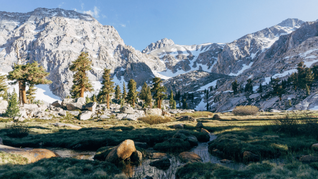
The hike to Lone Pine Lake follows the famed Mount Whitney Trail, but no permit is required unless you hike beyond the lake. You’ll wind your way through pine forest and granite switchbacks with views of Lone Pine Creek rushing below. At 9,900 feet, the lake sits in a wide glacial bowl with crystal-clear water and a panoramic view of the Sierra crest. Great for early-season hikers testing altitude legs.
2. Meysan Lakes Trail
Town: Lone Pine
Trailhead: Meysan Lakes Trailhead (near Whitney Portal)
Distance: 10.8 miles
Elevation Gain: ~3,976 feet
Route Type: Out and back
A steep, remote trail that leads into a rugged alpine basin rarely touched by crowds. The climb is relentless, the exposure real, and the rewards unmatched—especially if you reach the upper lakes. Water sources can run dry in late season, so plan accordingly and prepare for a strenuous, rewarding journey.
3. Lower Boy Scout Lake (Mountaineers Route)
Town: Lone Pine
Trailhead: Whitney Portal (Mountaineer’s Route)
Distance: 5.8 miles
Elevation Gain: ~2,500 feet
Route Type: Out and back
This is not your average lake hike. The route includes exposed class 3 ledges, loose scree, and serious alpine conditions. It’s beautiful and brutal, and not recommended unless you have experience with mountaineering or high-angle terrain. Helmets are highly recommended.
4. Mt Whitney Portal Recreation Patrol
Town: Lone Pine
Trailhead: Lone Pine Campground
Distance: 6.7 miles
Elevation Gain: Varies
Route Type: Out and back
You don’t need to summit to enjoy the Whitney Trail. Hike as far as your legs and lungs take you—whether that’s the North Fork turnoff, Bighorn Park, or Lone Pine Lake—and enjoy cooler weather and fewer crowds in spring, fall, or winter. A great way to sample the highest trail in the lower 48 without permit drama.
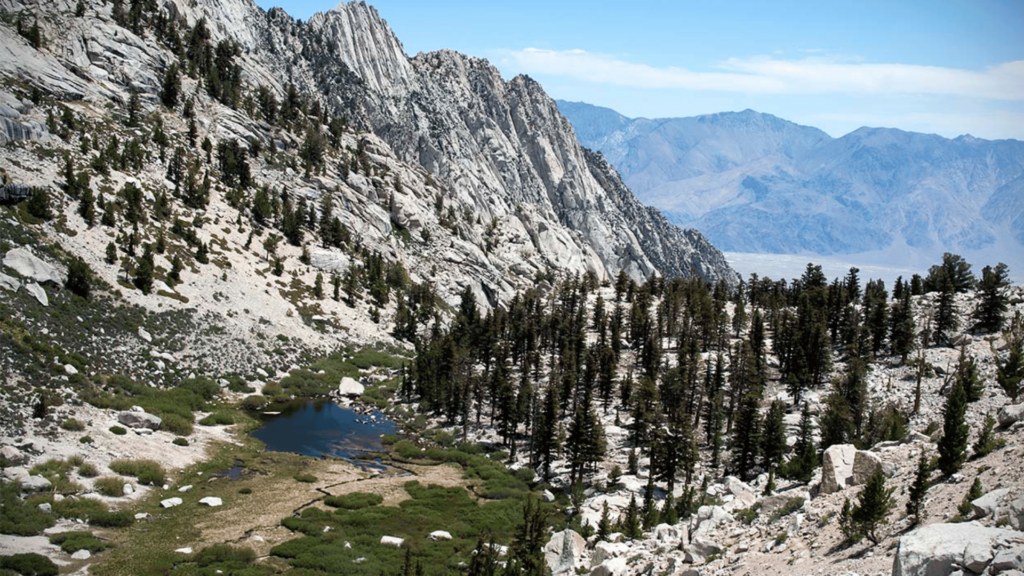
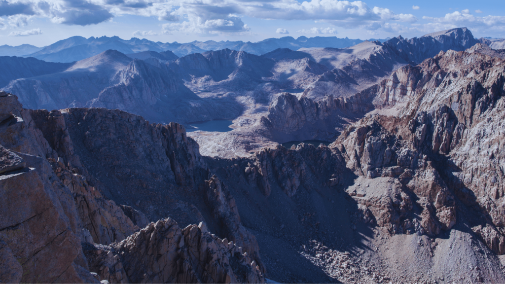
5. Cottonwood Lakes
Town: Lone Pine
Trailhead: Horseshoe Meadows > Cottonwood
Distance: 16.2 miles
Elevation Gain: ~2,677 feet
Route Type: Out and back
A high-altitude stunner that brings you to a basin dotted with turquoise lakes below the towering mass of Mt. Langley. This hike starts above 10,000 feet and offers immediate access to wildflower meadows, cold creeks, and endless granite. A must for anglers, photographers, or anyone craving a full-day alpine escape without a permit.
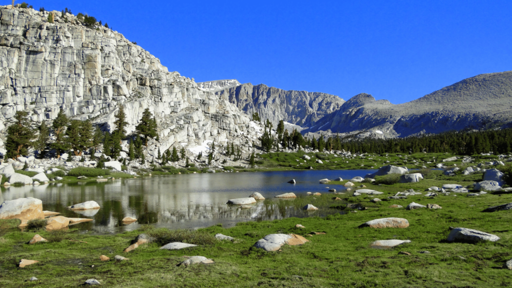
6. Cottonwood Pass Loop

Town: Lone Pine
Trailhead: Horseshoe Meadows > Mulkey
Distance: 10.8 miles
Elevation Gain: ~1,469 feet
Route Type: Out and back
This mellow pass hike offers broad views of the Golden Trout Wilderness and a gateway to the Pacific Crest Trail. With its moderate grade and high trailhead, it’s a great choice for getting your lungs and legs ready for bigger Sierra objectives. Expect big skies, breezy pines, and plenty of space to roam.
7. Mt. Langley via Cottonwood Pass
Town: Lone Pine
Trailhead: Horseshoe Meadows > Cottonwood
Distance: 25.1 miles
Elevation Gain: ~6,201 feet
Route Type: Out and back
One of California’s 14ers—and no permit required. This trail passes through the Cottonwood Lakes basin before climbing steep talus and sand to the summit. It’s a challenging but rewarding high-altitude mission for seasoned hikers, with killer views from the top of the Eastern Sierra spine.
8. Tuttle Creek Ashram Trail
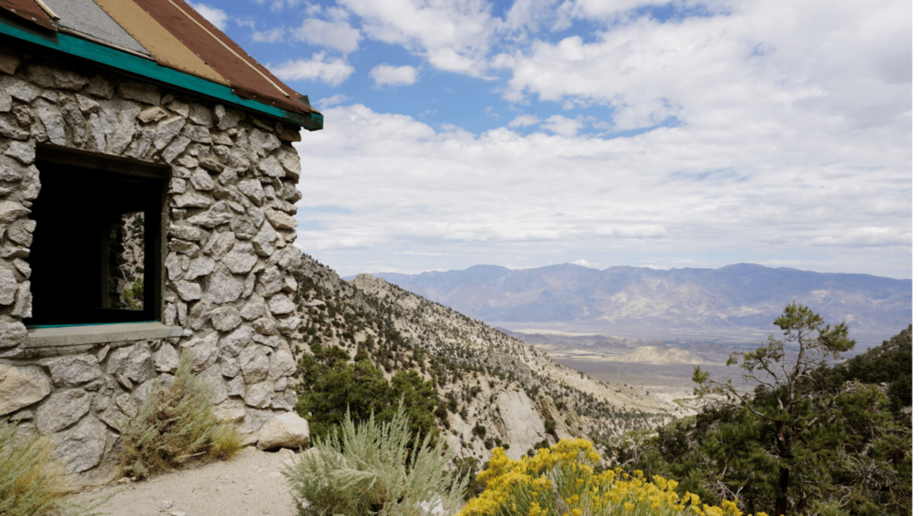
Town: Lone Pine
Trailhead: Granite View (4×4 strongly recommended)
Distance: 3.9 miles round-trip
Elevation Gain: ~1,479 feet
Route Type: Out and back
This peaceful stone ashram was built in the 1930s and still radiates a strange stillness. The trail is steep, dusty, and quiet—and the road is rough, so most visitors park below and add mileage. The ashram sits alone in a granite amphitheater, surrounded by soaring peaks. It’s weird in the best way.
9. Mobius Arch Loop Trail
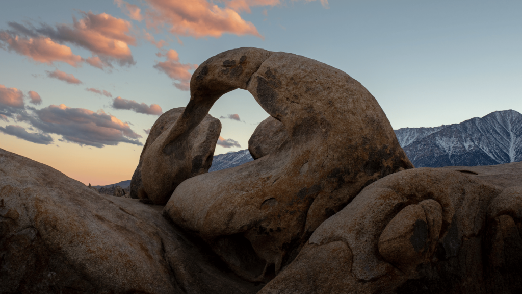
Town: Lone Pine
Trailhead: Alabama Hills
Distance: 0.6 miles loop
Elevation Gain: ~42 feet
Route Type: Loop
A short walk to the most iconic rock formation in the Alabama Hills. Mobius Arch perfectly frames Mt. Whitney on a clear day and is an ideal sunrise or sunset spot. Please stay on trail and off the arch itself—this place is fragile and deeply loved.
10. Movie Road Trail
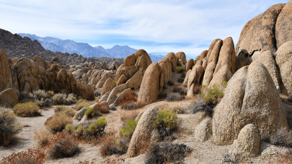
Town: Lone Pine
Trailhead: Alabama Hills
Distance: 17.1 miles loop
Elevation Gain: ~2,503 feet
Route Type: Loop
This scenic loop takes you through the heart of the Alabama Hills. Great as a winter hike or gravel bike ride when high country trails are snowed in. Expect towering granite, cinematic backdrops, and very few people on foot.
Last but not Least #leavenotrace
Please recreate responsibly. Stay on trail, pack out all trash, and avoid picking wildflowers or disturbing wildlife. Respect the land, the people who steward it, and the hikers around you.
AWE Disclaimer: Recreation activities may involve inherent risks, including but not limited to changing weather conditions, challenging terrain, wildlife encounters, and other unforeseen hazards. Visitors should check with local land management agencies or authorities for up-to-date information on trail conditions, access, permits, and regulations before planning their trip. Always prioritize safety by being prepared, carrying adequate supplies, and following Leave No Trace principles to protect the environment. Respect local rules, private property, and other visitors. This post is for informational purposes only, and participation in any activity is at your own risk.